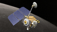
 The
goal of this project is to provide lunar and related reference systems
with an accuracy meeting all requirements of modern geodesy, astronomy,
and future exploration. Our work will be based on refined lunar models
and novel integrated data sets. Laser ranging data to the lunar surface
and to orbiters shall be combined to determine parameters of the
Earth-Moon system, i.e. librational motion and tidal deformation as well
as relativistic parameters. The resulting lunar orbit will not only
contribute to improved solar system ephemeris, but serves as dynamic
realization of the celestial reference system to be combined with VLBI
based systems. As one product, an improved Moon-wide uniform coordinate
knowledge will be realized analyzing image and altimeter data from lunar
missions like Lunar Reconnaissance Orbiter (LRO). Simulations of radio
tracking and laser ranging data from dedicated lunar landers shall be
performed. We will fully exploit the potential of novel data sets and we
will explore synergies by combining these data with classical LLR
measurements. Moon-related reference systems serve as indispensable
element to link terrestrial and celestial reference systems. They are
the prerequisites for further advances in Lunar science and space
exploration. Moreover, this project prepares the application of
established methods for mapping and surveying the Earth to
extra-terrestrial bodies.
An overview of the LLR related part can be found on the LLR website at IfE.